De-risking exploration seminar, 24th November 2017
Mineral exploration holds inherent risk both geological and political. How can we manage and mitigate this risk in modern exploration? …
Continue ReadingIGS awarded 2nd place for Frank Arnott award
IGS has been awarded 2nd place in the prestigious Frank Arnott Award in a ceremony at the Exploration 2017 conference in Toronto.
Continue ReadingUnlocking geoscience data – Uganda Pilot Project the key to African resource development
Resource development relies on geoscience data (‘geodata’). In Africa, access to useful geodata is often slow, expensive and unreliable. This discourages potential investors and leads to a slow rate of development.
Continue ReadingIGS attends Mining Mazma in India
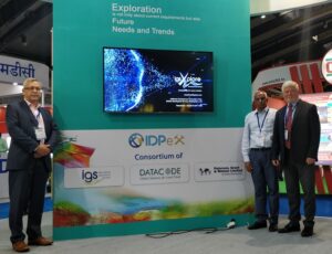
IGS attended the Government of India (Ministry of Mines) sponsored Mining, Exploration, Convention & Trade Show in Bangalore (Mining MAZMA, 2017), 14th – 16th September 2017 held in the Bangalore International Exhibition Centre. IGS is part of a joint-venture India- registered company known as IDPeX Pvt. Ltd. comprising Datacode, an Indian-registered geodata management consultancy, and software reseller and PGW, (Paterson, Grant & Watson Limited), a geophysical consultancy based in Toronto, along with IGS. IDPeX was well represented at the show having a prominent centre stage stand and also presented 3 papers entitled ‘Attracting Exploration Investment – The Pathway to Success’ by Peter Zawada (MD of IGS), ‘Understanding Airborne Geophysical Data (Acquisition, Processing, Interpretation and Application)‘ by Bill McCourt (Technical Director of IGS) and Stephen Reford (President of PGW) and ‘Promoting your Geodata to the World – Applications, Products and Services’ by S. Karunakar Rao (CEO of Datacode).
India’s exploration and mining sector is at a nascent stage of development and although contributing just 1.36% (2016/17) to the GDP of the country (net of oil and gas earnings), of which 0.7% is ascribed to coal and lignite, it is undergoing rapid transformation to expand its contribution to the nation. Reform of its Mining Code and Policy has seen important changes and further amendments are anticipated. The State Governments are expected to play an important role in attracting exploration investment. IGS is planning to expand its geodata, capacity building and mineral promotion services on the sub-continent both at a National and State level through the joint venture company of IDPeX.
Latest prospectivity map produced
IGS has recently completed the latest of a series of prospectivity maps, this time for Cu porphyry potential in the Malanjkhand area of India. These maps, produced by Xplore – our semantic technology-based mineral prospectivity software – highlight the most prospective areas for particular mineral deposit model types.
Almost 50 different mineral deposit models can be rapidly analysed using existing baseline datasets and well-established, peer reviewed mineral deposit model characteristics. The prospectivity maps produced are of great help in aiding the identification of prospective areas for governments, as well as exploration companies seeking to enter new markets, or to delineate more detailed areas of interest.
IGS attends EXPO 2017 in Astana
IGS recently attended a series of meetings in Astana with senior members of KazGeology and the Ministry for Investments and Development as part of our ongoing discussions to help develop the Kazakh minerals industry. Meetings were also attended by our partners, including the Natural History Museum and Geosoft, as well as the Department of International Trade, who helped organise the event. The events were hosted by the UK pavilion at EXPO 2017.
Continue ReadingIGS attends National Mining Summit in Nigeria
IGS recently attended the National Mining Summit held in Abuja, Nigeria, speaking in a panel discussion on the importance of acquiring and managing geodata to aid in mineral exploration. The event was well attended by government and private companies and was opened by the Acting President of Nigeria, Prof. Yemi Osinbajo, and closed by the Minister of State for Mines and Steel Development, Abubakar Bawa Bwari.
Continue ReadingIGS welcomes new starters
IGS is pleased to announce the arrival of two new members of staff to our team.
Duncan Hall has been appointed as a Mapping Geologist and will initially be working on our project in DR Congo. Duncan completed his undergraduate BSc in Geology as well as a PhD from the University of Stellenbosch in South Africa, with his thesis titled “Structural controls on granitic magma migration in the Damara Belt, Nambia”.
Zahid Anwar has been appointed as a Software Engineer and will work on our Xplore Prospectivity Analysis tool to help further develop Xplore with its functionality and capability. Zahid has a background in developing apps for mobile phones and tablets.
IGS chairs session at MINEX Asia 2017
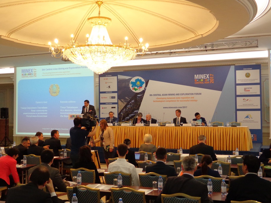 IGS chaired a session on ‘Improving Investment Returns in Exploration’ at the MINEX Asia conference in Astana, Kazakhstan, between 19-20th April.
MINEX Asia is the most important mining-related event in central Asia which brings together experts to discuss current events, trends, and policies throughout the region.
IGS is partnering with the Natural History Museum (NHM) in a proposal in Kazakhstan, and Prof. Reimar Seltmann from the NMH delivered a presentation at the conference which discussed using prospectivity maps developed by IGS Xplore to find new mineral deposits in Kazakhstan.
We look forward to continuing our discussions with our colleagues and supporters at the UK’s Department for International Trade, the NHM, and our Kazakh co-partners.
Public-private partnership to open Geodata access for Africa

Delegates attending African Geodata Workshop in Uganda
IGS is pleased to announce its participation in a pilot project aimed at improving the availability, accessibility and usability of geoscientific data (geodata) to guide resource investment in the Eastern African Region. The pilot project, and launch of a geodata portal hosted by Uganda, will be conducted under the auspices of the African Union Commission (AUC), and is a collaborative partnership between the British Geological Survey (BGS), Geosoft Inc., IGS Ltd., the Uganda Geological Survey and the Uganda Chamber of Mines and Petroleum.
IGS was represented by Dr Frik Hartzer, whilst Dr Peter K. Zawada, Managing Director of IGS stated “IGS was honoured to have been involved in developing the workshop agenda, and we’re pleased to be part of the committee implementing the pilot geodata project for Uganda. Public-private partnerships are a vitally important way of ensuring the availability and accessibility of geodata, and creating added value to that data, to attract inward investment in the mineral exploration sector for Africa. Exciting time lies ahead where geodata is used to create wealth and to improve the quality of life of Africa’s people.”
The workshop and pilot project are guided by the aspirations and principles of the Africa Mining Vision (AMV) and Agenda 2063, which recognizes geodata as an imperative for future development of Africa’s extractives, agriculture, forestry, fisheries, infrastructure and tourism sectors.
The initiative will be based on a public-private partnership business model for the generation, management and ownership of geodata by participating countries and it is expected to be piloted in other African countries.