
Groundwater
The geology of the subsurface determines how much water can be stored in the ground and how readily it flows through geological units. Aquifers, geological units which contain groundwater that can be extracted, provide over 50% of water used globally for drinking, irrigated agriculture and industry. Increasing pressures from climate change, increasing population, industrialisation and intensive agriculture mean it is vital to better understand the geology and structure of aquifers to manage their recharge, water quality and sustainable extraction. IGS experts can work closely with hydrologists and hydrogeologists providing geological expertise.
IGS can provide a range of services including:
- Regional and local field investigations, including geological field mapping
- 3D geological modelling
- Airborne and ground electromagnetic geophysical surveys
- Remote sensing
- Core logging
Geological Modelling
3D geological modelling creates a virtual three-dimensional representation of the subsurface, allowing geologists to visualise and analyse the subsurface stratigraphy and structure. Model creation involves integration of diverse geodata sets, including well data and geological mapping.
IGS experts can develop 3D geological and structural models in Leapfrog Geo and provide a range of derived products from the models, such as cross-sections and video fly-throughs, enhancing visualization of the subsurface in the model.
Applications of 3D geological modelling include:
- Mineral deposits: to determine the location and geometry of deposits and to help define the volume and concentration of minerals.
- Groundwater: to determine the volume and structure of aquifers to identify artesian conditions, flow pathways, recharge zones and contamination risks.
- Oil and gas: to determine the structure of reservoirs and the volume of the reserves.
- Geotechnical engineering: to assess subsurface conditions for infrastructure development and construction projects.
With several years of experience providing Geochem QA/QC services using cutting edge approach; IGS is known globally as the expert in QA/QC, technical evaluation and reporting regarding a geochemical survey. We bring the disciplines of geology, geophysics and geochemistry together through integration, interrogation and analysing all available geoscience data by unifying geological, geophysical, and geochemical datasets for promoting activities and investment strategies.
We have the expertise to assist our clients in the following areas:
- Review of project deliverables including field database, archive sample delivery/handover, technical reports and working procedure manuals as well as planned activities
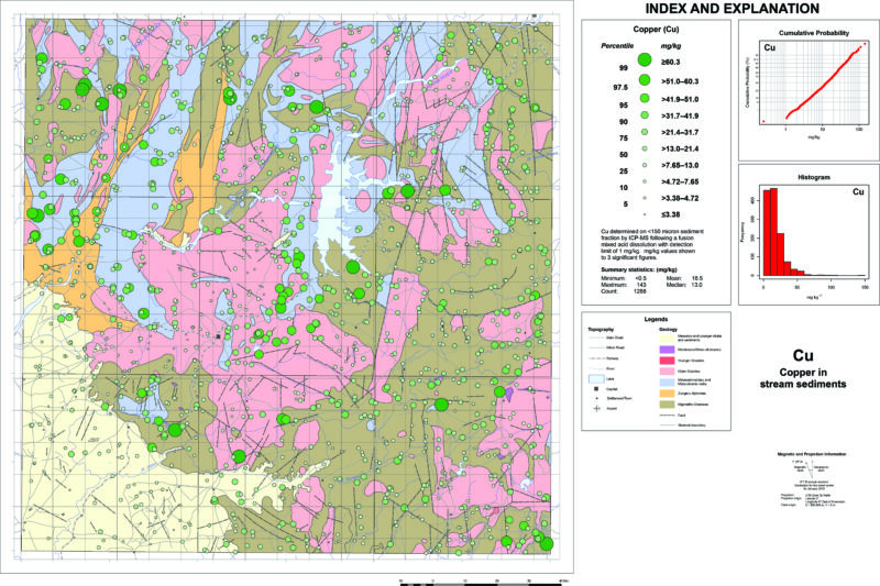
- Verification / validation of project deliverables including sampling site maps, chemical analysis results, statistical analyses and geochemical anomaly maps
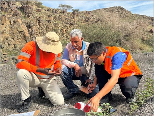
- Field inspections and review of geochemical data
- Preparation of training materials to support capacity building through workshops and training activities in the protocols of geochemical surveys and mineral exploration
- Technical advisory consultations
QA/QC workflow for airborne magnetic and radiometric surveys
Below is an example of the typical QA/QC steps that IGS applies on geophysical surveys (as independent QC consultants)
QA/QC workflow for airborne magnetic and radiometric surveys
Pre-Survey / Survey Commencement
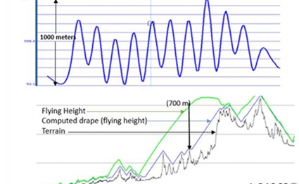
- Evaluate logistical, safety, emergency response, permitting, insurance, crew qualifications, flight planning, drape surface, aircraft suitability, survey equipment lists, and data security measures.
- Report findings and recommendations to the Client to optimize safety, quality, and efficiency.
- Review calibration results for navigation systems, aircraft and base station magnetometers, and radiometric sensors.
- Validate accuracy, noise levels, synchronization, and spectral performance.
- Carry out site visit to Inspect survey aircraft, equipment, calibration/test results, survey procedures, and crew understanding of project requirements.
- Review initial production data for quality and deliverables standards compliance
- Compare datasets in multi-aircraft surveys via system comparison lines.
Production (Field) Data QC
- Conduct regular audits of navigation (line separations, flight path adherence, altitudes, GPS quality), magnetic data (sensor consistency, noise, gaps, drift), base station data (location suitability, diurnal stability, noise, filtering), and radiometric data (daily consistency tests, spectral drift, resolution, sampling rates, corrections).
- Address issues through data reprocessing or survey reflights.
- Verify calibrations and tests of any replaced equipment, survey coverage completion, and quality of final production data.
- Review interim and final navigation, magnetometer, and radiometric test results. Confirm post-survey calibrations meet standards.
- Approve field data for project demobilization.
Deliverables QC
- Assess processing methodologies, levelling techniques, database structure, gridding procedures, coordinate references, and draft map templates.
- Review interpretation methods and results (where applicable)
- Validate final magnetic and radiometric databases, grids, enhanced products, elevation models, maps (digital and hardcopy), interpretation results, and survey reports for completeness, accuracy, and conformity to specifications.
IGS also offers QA/QC on other types of surveys e.g. EM, Gravity/AGG etc.
Along with standard checks above for mag/rad surveys (navigation and magnetometer systems), additional QAQC procedures for active and passive EM systems, gravity and gravity gradiometry systems are offered.
EM Systems (TDEM, FDEM, passive EM systems)
- Review instrumentation including sampling rate, sensitivity, noise envelopes. Evaluate EM noise characteristics independently.
- Review system specific calibrations and test lines results.
- Verify channel widths, numbers, frequencies.
- Perform EM sensor orthogonality checks (e.g. for FDEM, AFMAG).
- Assess signal-to-noise ratios and noise levels (including 50Hz and atmospherics monitors)
- Verify EM system motion (Tx-Rx relative motion) and corrections for this.
- Compare primary field measurements (Tx-Rx) for consistency.
- Check EM data quality (gaps, artifacts) and repeatability.
- Conduct resolution and terrain clearance assessments.
- Validate flight velocity and transmitter spacing.
- Verify sensor coil orientation/directionality for rover and base (AFMAG)
- Review tipper in-phase and quadrature for all EM channels; review in-phase -rotated divergence for low/middle/high frequencies (AFmag)
- Perform independent EM inversion or conductivity depth imaging (CDI) as needed.
Gravity/Gravity Gradiometry Systems QA/QC
Note the following are generalised steps and more specific QC steps are applied depending on a particular system and whether a gravimeter, gradiometer (incl. full and partial tensor systems of different generations).
- Check that raw data is archived, and instrument noise is minimized.
- Validate that noise levels meet survey specifications (defined with appropriate filter cut-offs).
- Conduct daily background/system drift checks and confirm zero-level stability.
- Assess daily/weekly test line results for repeatability and multi-channel consistency.
- Verify flight-to-flight and line-to-line data consistency in base level, amplitude, and wavelength.
- Verify that GPS positional and acceleration measurements meet specifications and GPS derived corrections effectively remove motion noise.
- Verify filtering and decimation of profile data is appropriate to retain signal fidelity.
- Apply terrain corrections using accurate (e.g. LiDAR) DEM and suitable density models, accounting for geology, ice and lake effects.
- In-field processing should generate image-quality grids (e.g., Bouguer, Free-Air, or gradients) sufficient to allow sign-off of data before demobilisation.
- For gradiometry systems, verify inline sums, consistent behaviour of redundant tensor components, appropriate long wavelength trends, quiescent noise consistency.
- Review turbulence levels and related noise.
Quality Assurance & Quality Control of RGP Projects
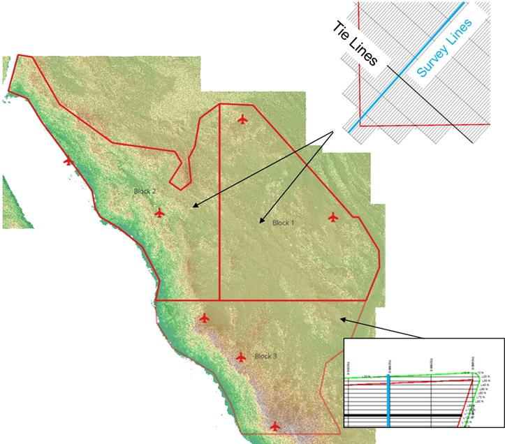
Survey design
Data products
IGS provides expert consultancy services across a broad suite of airborne (including UAV/drone) geophysical methods such as magnetics, radiometrics, gravity, gravity gradiometry, time and frequency domain electromagnetics, magnetotellurics and lidar.
Our services include:
- Develop technical specifications, writing RFQ/RFP documents, technical evaluation of tender responses and technical support with contract negotiations.
- Provide independent assessment of cost/benefit of geophysical survey propositions.
- Review and approval of survey plans, drapes, pre-survey calibrations, aircraft and survey equipment inspection and signoff.
- QA/QC of field data acquisition including all interim calibrations
- Establishment of calibration sites
- QA/QC of processed data and all final products from survey
- Interpretation of airborne geophysics including litho-structural interpretation, advanced processing, modelling and inversion.
- Provide guidance for map publication standards and templates
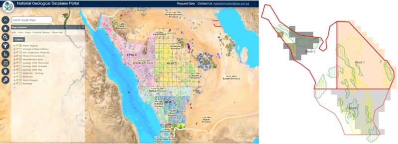
- Provide ad hoc technical advisory services such as product preparation for portal/national data server, metadata specification, prospectivity analysis, etc.
- Training – both classroom presentation and on-the-job workshops
IGS has extensive experience as an independent consultant supporting national geological survey clients in running major airborne geophysical programs.
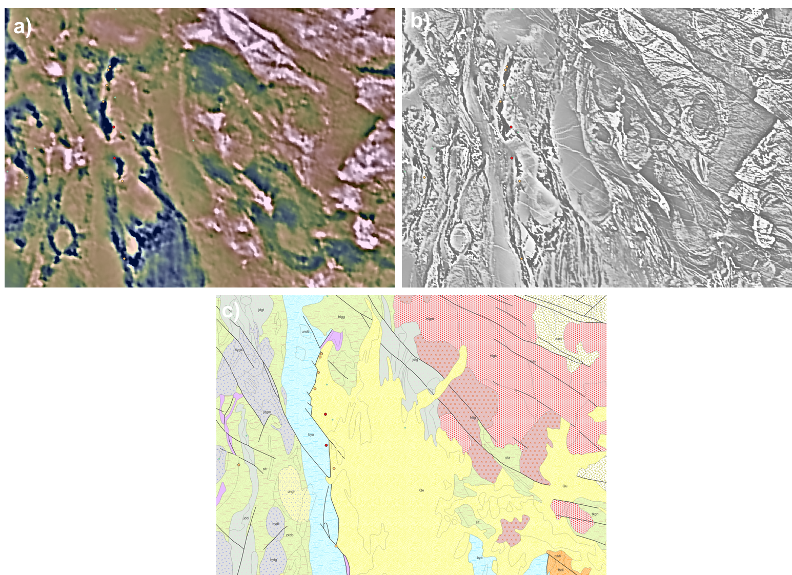
Figure: Example of data from recent Saudi Geological Survey program in which IGS carried out technical supervision and QA/QC. a) Legacy magnetic data (RTP magnetics colour + 1VD grey scale composite) b) NEW magnetic data – 1VD of RTP magnetics c) Legacy geology map (1:1 million).
IGS provides quality control and interpretation of airborne electromagnetic data – for both time domain (TEM) and frequency domain (FEM) systems. We provide:
- Data editing, cleaning, filtering.
- 1D modeling of TEM (and FEM) data collected by commercially available systems such as: Tempest, VTEM, SkyTEM and Xcite, etc.
- Decay constant analysis.
- Visualization of results e.g. fence diagrams of inverted sections to visualize the variation/correlation of the conductivity depth sections from line to line.
- Conductivity maps at various depth levels
- Overburden thickness mapping.
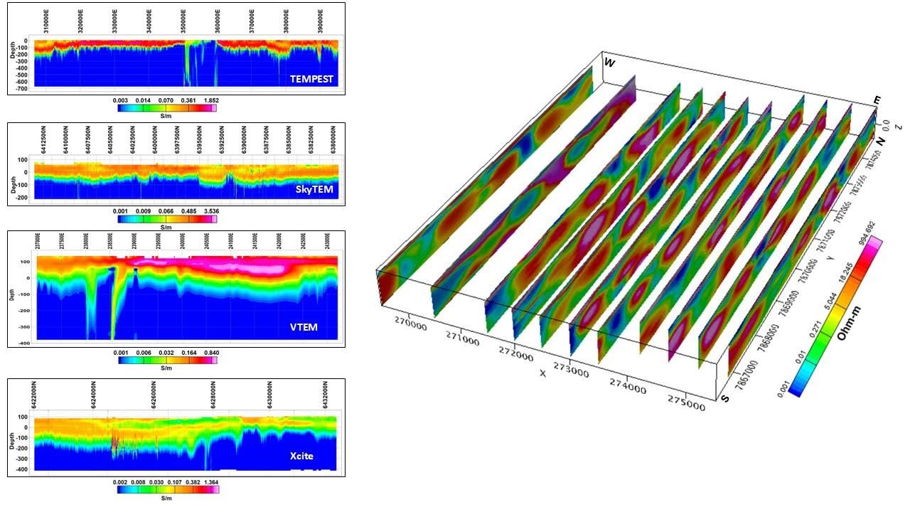
Example of 1D layered earth inversions run by IGS on data from various TEM surveys and systems (left) and 3D view of fence diagrams of inverted sections, CGG/Xcalibur Tempest AEM data (right).