Vacancy for experienced Senior Geophysicist
![]() Due to our continued success in attracting new business, a vacancy has arisen for an experienced Senior Geophysicist to join our team at our office in Keyworth, near Nottingham, UK. Further details of this job can be found on Earthworks-jobs.com at the following link: http://www.earthworks-jobs.com/mining/igsint16101.html. The deadline for applications is the 28th October 2016.
Due to our continued success in attracting new business, a vacancy has arisen for an experienced Senior Geophysicist to join our team at our office in Keyworth, near Nottingham, UK. Further details of this job can be found on Earthworks-jobs.com at the following link: http://www.earthworks-jobs.com/mining/igsint16101.html. The deadline for applications is the 28th October 2016.
IGS wins project in DR Congo
 IGS is pleased to announce the securing of a new contract in the Democratic Republic of the Congo (DRC). This project, part of the World Bank-funded PROMINES Project, is to undertake an airborne geophysical survey of six sites in the DRC and to interpret the data derived from this survey. IGS is leading this project and partnering with PGW of Canada and NRG of South Africa.
Dr Peter Zawada, Managing Director of IGS, said “We are pleased to have won this work and to continue to expand our operations in Africa. We are hopeful of securing other work in the DRC in the near future and to further expand our business here and in other parts of Africa”.
New IGS Xplore prospectivity maps for Botswana
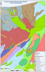 IGS has recently released a series of base metal prospectivity maps for parts of Botswana produced by IGS Xplore using free geodata available on the recently launched Botswana Geoscience Portal, hosted by Geosoft.
These maps highlight favourable areas for copper, lead, and zinc mineralisation associated with different mineral deposit styles and can be used to prioritize future exploration or mapping programmes, or to help delineate mining tenement areas.
The IGS Xplore Prospectivity Maps are free to download from the Botswana Geoscience Portal. Each download includes a map in image and shapefile / layer formats and a mineral prospectivity report which provides details of the analyses and the prospectivity results. The Portal can be accessed by following this link.
IGS Xplore – Raising Investment to Go Global
IGS Ltd is pleased to announce that it has recently completed a significant investment of private capital which will be used to advance the development of IGS Xplore – its proprietary software service that de-risks early stage mineral exploration.
IGS Xplore is an expert system developed by IGS Ltd over the past 2.5 years which was formally commercially launched in early 2016 and which has already received a number of critical endorsements from high profile clients. Xplore is unique in the mineral sector and provides essential prospectivity analysis across a wide range of commodities, covering all the main globally recognised mineralization models, quickly and cost effectively. The market in which Xplore will operate includes the junior, mid-cap and major exploration companies, mining finance/institutional and investment professionals, as well as government departments.
The proceeds of the investment will be used to expand Xplore’s global commercial footprint and to further enhance its functionality. We aim to make Xplore the first ‘port of call’ prospectivity service for early stage explorers.
Afghan project graded A+ in DFID review
 We are pleased to announce that the latest Annual Review of the ESSP (Extractive Sector Support Programme in Afghanistan has graded the programme as A+. This review, undertaken by DFID, the funders for this work, is the second year in a row that this grade has been achieved, and is a tremendous accomplishment for all involved in this work.
Despite challenges, our projects continue to make good progress at both the Ministry of Mines and Petroleum and the Afghan Geological Survey (AGS). Laboratory equipment for the AGS projects will begin to arrive in August which will be followed by training AGS staff on how to use this equipment, and we are hopeful to refurbish several other pieces of laboratory analytical equipment as well, which should be more cost effective than replacing them with new items.
More details about this work can be seen on the DFID website here.
IGS visits African Minerals and Geoscience Centre in Tanzania
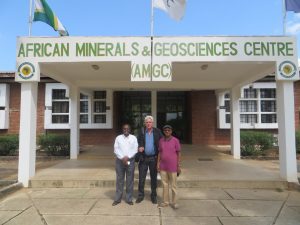 Frik Hartzer of IGS recently visited the African Minerals and Geosciences Centre (AMGC) in Dar Es Salaam, Tanzania. The centre was established in 1977 as a regional (South and East African) centre of minerals knowledge (SEAMIC). In recent years it has expanded its mandate and is now an information and training centre for all aspects of African geology and geosciences. It was recently evaluated as a potential centre of geoscience excellence, as part of the implementation of the African Minerals and Geosciences Initiative (AMGI) strategy for the African Mining Vision (AMV). The centre is well situated at Kunduchi Beach away from the hustle and bustle of central Dar Es Salaam and has excellent conference and training facilities. Frik was hosted by Ibrahim Shaddad (Director General) and Mesfin Wubeshet Gebremichael (Geoinformation Service Manager).
IGS employ GIS specialist
 IGS is pleased to announce the appointment of Paul Turner as a GIS specialist who also has expertise in geological cartography. Paul previously worked at the British Geological Survey for 37 years and has extensive experience in Africa having worked in Zimbabwe, Zambia, Ghana, Tanzania and South Africa, as well as Papua New Guinea.
Paul will be helping our IGS Xplore team develop and refine our products using his knowledge of map production and GIS, as well as working on overseas projects when appropriate.
On his appointment at IGS, Paul said “I’m looking forward to working with my colleagues at IGS and applying my experience to new challenges”.
Dr Peter Zawada, Managing Director of IGS, said “I am pleased to welcome Paul to our team and I am confident that Paul’s skills will add considerable value to not just IGS Xplore products, but also to our other international projects”.
Cameroon project progresses
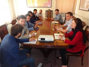
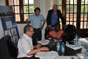 Frik Hartzer of the IGS recently attended a contract meeting in Yaoundé, Cameroon regarding the current World Bank-funded project titled “La supervision d’un programme de cartographie géologique et géochimique et la mise en place d’un Système d’Informations Géologiques et Minières au Cameroun”. IGS formed a consortium with the Council for Geoscience (CGS) of South Africa to supervise the project, while the geological mapping, geochemical surveying and the establishment of a GIS-based database will be conducted by the French Geological Survey (BRGM). During this meeting a final agreement was reached with BRGM regarding the specifics of the program during the following 36 months.
IGS and NTU awarded outstanding grade
IGS and Nottingham Trent University (NTU) are proud to have been awarded the highest grade of ‘Outstanding’ by the Knowledge Transfer Partnership (KTP).
This award recognises the excellent work undertaken by IGS and NTU from 2013 to 2016 in helping to develop the technical specifications for our IGS Xplore system.
The official KTP project brief was ‘To design, implement and provide on-going development of a commercial, web-enabled geodata delivery system (database) to support the international mineral exploration sector’.
The aim of the KTP is to strengthen the competitiveness, wealth creation and economic performance of the UK by the enhancement of knowledge and skills and the simulation of innovation through collaborative projects between business and the knowledge base.
Project in Lao PDR commences
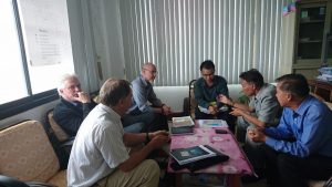 A “kick-off” workshop was held in Vientiane Lao PDR on the 17th May to mark the start of a World Bank Project named; the Acquisition and Development of Geo-data infrastructure within selected areas in Lao PDR. A consortium of IGS, GTK (Finnish Geological Survey) and PGW (Patterson, Grant & Watson) was awarded the tender for this project which will last until the end of 2017. The project involves the acquisition of high-density geophysical data followed by geological mapping of the same area of about 2000 km² in the north-central part of Lao PDR. The role of IGS will be primarily to conduct the geological mapping and training, and to assess of the mineral resources of the area, as well as assisting in the management of the project.
The May workshop held in Vientiane was attended by representatives of the various consultants (IGS, PGW, GTK), sub-contractors (SGL), the Ministries of Energy and Mines, Natural Resources, and Defence, as well as from the Prime Minister’s Office and the National Geographic Department. IGS was represented by Frik Hartzer. At the meeting the basic program and scheduling was discussed with the emphasis on the geophysical survey which is to start as soon as the necessary permits are obtained. Geological mapping will start as soon as the results of the geophysical survey becomes available. This project marks the beginning of a new chapter in the development of the Lao geological infra-structure, as well as the involvement of IGS in Asia.